165-year-old map on display at National Museum of Korea, offering glimpse into how Koreans understood the peninsula
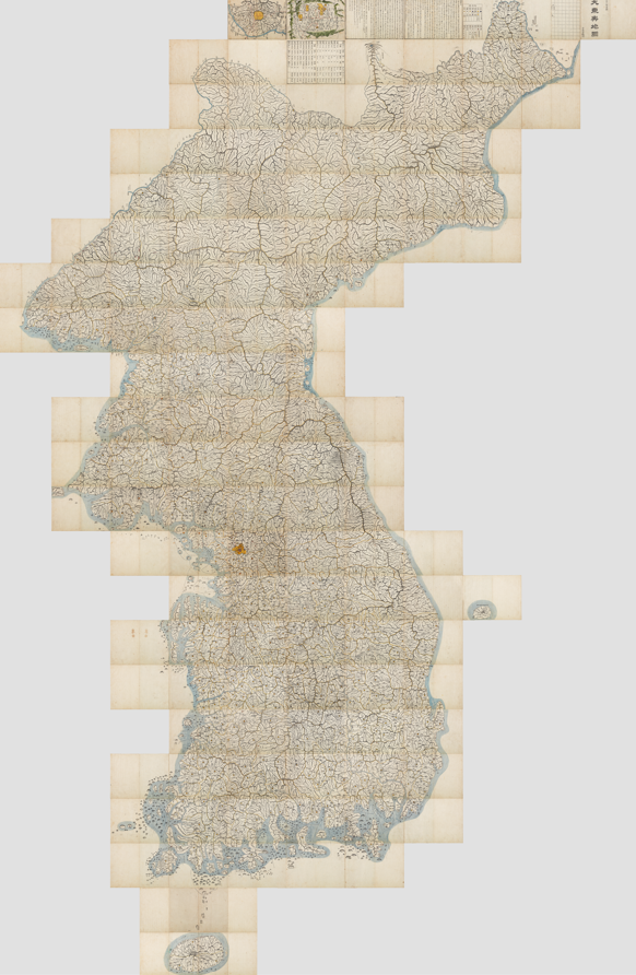
How did Koreans understand the geography of their country centuries ago? A large map of the Korean Peninsula put together by geographer Gim Jeong-ho in 1861 during the Joseon era marked a milestone in Korean geography history.
The National Museum of Korea on Feb. 12 unfurled the map, known as Daedongyeojido — spanning 6.7 meters in height and 3.8 meters in width — in the museum's permanent gallery on the first floor, bringing together all 22 sections of the map.
The map divides the Korean Peninsula into 22 horizontal sections, which combine to form a single image of the territory.
Widely regarded as a culmination of Korea's long-standing tradition of mapmaking, Daedongyeojido is known for its detailed depiction of mountain ranges and waterways, as well as a road network marked at intervals of 10 ri — roughly 4 kilometers — which allowed users to estimate actual travel distances, according to the museum.
The map marked a turning point in Korean cartography by transforming territorial knowledge into a standardized, reproducible system of spatial information that could be used for travel, administration and governance. Its use of woodblock printing is another distinguishing point from previous hand-drawn maps, allowing for wider dissemination and portability.
"Presenting Daedongyeojido not as a bound book but as a complete geographical representation offers a valuable opportunity for visitors to gain a deeper appreciation of the scientific and artistic achievements embedded in Joseon-era cartography," said You Hong-jun, director of NMK.
yunapark@heraldcorp.com